Showing posts with label Remote Site California. Show all posts

Sunday, October 9, 2016

Gumboot Campground


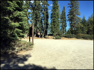
Very brief description:   Primitive camping on the north side of a shallow alpine lake in an outlying area, but available by car.  Bring your own water. Poor signage in the area.  The campground itself no longer has an identifying sign as viewed in the photo below.  

Open Dates:  Depending on snow pack, Gumboot Campground is open from June to October.

Number of Campsites:  Six undeveloped sites with user made fire rings and some user made pathways.  Suitable for small trailers, campers and tents.  Max length of trailer 20 to 25 ft. but curves along the road can be tight and turnarounds will be minimal.  Parts of the road leading to the campground is in poor condition, although paved, and sections are very narrow.

Dispersed Camping:  There are a number of dispersed camping sites available for free camping as you travel the road west of the Lake Siskiyou once reaching the National Forest boundary as you head toward Gumboot Lake.  Many of these sites are right along the road; others are located on spur roads.  For detailed information on dispersed camping contact the Ranger Station or the website.
 
Length of Stay:  Length of stay is not posted, but likely 14 days.

Fees:  None.  Free.

Affiliation:  National Forest Service

Location/Address:  Gumboot Lake is approximately 16 miles from Mt. Shasta City on local roads.  From Mt. Shasta City at Interstate 5 take the Central Mt. Shasta exit and go West on West Ream Avenue.  Turn South on West Barr Road (Forest Route 26) towards Lake Siskiyou.  Follow West Barr Road and drive over Box Canyon Dam and drive past Lake Siskiyou.  Continue on the road and pass the entrance to Lake Siskiyou Campground.  From there continue along the same road and it will turn into Forest Route 40N26.  This road follows the canyon of the South Fork of the Sacramento River.  In places the road is very winding and narrow, drive carefully and watch for oncoming traffic and wildlife.  When you reach a fork in the road at about 15.5 miles look for a fork in the road, take the road to the left for ½ mile to Gumboot Lake.

Elevation:  Approximately 6,050 ft.
 Below is the parking and turn around area     
Contact Information
U. S. Forest Service
Mt. Shasta Ranger Station
204 West Alma
Mt. Shasta, CA  96067
(530) 926-4511

Amenities:
  • ·       Pit toilets
  • ·       User made fire rings
  • ·       Hiking
  • ·       Scenic


General Description:  Quiet and serene small alpine lake surrounded by a mixed conifer forest.  The lake sits in an open area with some grasses around.  A second, but smaller lake is nearby to the West.  A 2 mile drive from the lake is available to the Gumboot trail-head of the Pacific Crest Trail.  Views of Mt. Shasta and the Trinity Alps can be seen.  A 2 ½ mile (one way) hike south on the Pacific Crest Trail one can view and explore the Seven lakes Basin.  Some individuals have stated they can receive cell service in the open area by the lake, but it may be dependent on the carrier.  Most cell service is unavailable past Lake Siskiyou (about 10+ miles).

Nearby Services:  (groceries, medical, etc.)  Food, fuel, water, camping or hiking supplies are available in Mt. Shasta City. (16 miles)  Supplies are also available in nearby towns such as Weed, Yreka, or Dunsmuir. Nearest supplies would be in Mt. Shasta City.


Emergency:  Full service Emergency in Mt. Shasta at Mercy Medical Center (16 miles) and Yreka, at Fairchild Medical Center.

Friday, May 27, 2016

Lover's Camp


Brief description:  Beautiful treed area in the Marble Mountain wilderness area.  Tent camping only.  Many hiking and riding trails in this area.  The camp has 3 areas, corrals for horses and/or mules for packing into the mountains, parking area for livestock trailers, and a nice paved parking area for autos.  Walk into campsites.

Open Dates:  Open in May to October

Number of Campsites:   8 tent sites

Length of Stay:  14 days maximum

Fees:  Free!

Affiliation: Klamath National Forest Service

Location/Address:  Camp is located approximately 24 miles from Ft. Jones, California off of Hwy 3 and Scott River Road.  From Yreka travel Hwy 3 to Ft. Jones, take the Scott River Road for approximately 14 miles to the Indian Scotty and Lover’s Camp turn off.  (Sign post is well marked at turn).  Travel past Indian Scotty Camp and continue on the one lane paved road for 8 miles.  Some parts of the road are steep, and it is a winding road.  Watch for oncoming traffic, there are turnouts available.  In the spring runoff some places the water may cross the road.  The campground has essentially 3 areas, the first is horse corrals, the second area has the sign for the campground and the area is available for camping and parking livestock trailers.  Continue past the camping area sign for about ¼ mile and there will be a large paved parking lot adjacent to walk in campsites.

Elevation:  4,300 ft.

Contact Information:

Klamath National Forest
Supervisor’s  Office
1711 South Main Street
Yreka, CA  96097
(530) 842-6131


Amenities: 
·       Vault toilets
·       Fire rings
·       Some tables
·       Parking area
·       Water for horses only, not potable!
·       Gather firewood locally
·       Fishing in nearby lakes
     Livestock corrals


General Description:  Located in the trees with views of the Marble Mountain Wilderness.  Tent camping areas only, walk in.  Deer, bears, and birds frequent the area.  No trash service, no drinking water.  Bring in your own water, as well as water for dowsing campfires.  Remove all trash you bring in as well as clean up after dogs, and pack out.  Dogs on leash only.  Summers are moderate.  Contact the Forest Service for Packing Outfitters who are authorized to operate in the area.  Many trails give access to the Marble Mountain Wilderness via Canyon Creek and Red Rock Trails.  This is a lightly used campground.


Nearby Services:  (groceries, medical, etc.)  Nearest fuel and food located in Ft. Jones, approximately 24 miles.  Nearest Emergency room access would be Fairchild Medical Center in Yreka, approximately 42 miles.  Major supplies available in Yreka, California (42 miles).

Friday, April 18, 2014

Red Bank Public Camp


Red Bank Public Campground
Near Forks of the Salmon and situated in a dense area of pine, Madrone and fir trees.  Campground sits adjacent to the North Fork of the Salmon River.

This campground is currently closed (June 2021)

Open Dates:  May - October

Number of Campsites:  5 campsites

Length of Stay:  14 days

Fees:  Free!

Affiliation:  National Forest Service

Location/Address:  Approximately 7 miles north east of Forks of Salmon on county route 1C01.  From Yreka, California drive on Hwy 3 to Fort Jones, California.  Continue on Hwy 3 to Etna, California. (*Part of this route is on a very narrow winding road with steep cliffs.) From Etna take Sawyers Bar Road and drive approximately 32 miles.  Campground will be on the left if traveling in west direction.  This campground can also be accessed from Happy Camp, California on Hwy 96.  From Happy Camp drive approximately 38 miles to Salmon River Road, continue for 17 miles to Sawyers Bar Road and drive 7 miles to campground.

Elevation: 2200 feet

Contact Information:
Klamath National Forest (Supervisor’s Office)
1711 South Main Street
Yreka, CA  96097
(530) 842-6131

Amenities:
  • River fishing, trout can be caught from the banks
  • Vault toilets at last visit were available

General Description:  Dispersed type camping.  No drinking water, no hookups, no showers.  Pack out garbage.  Beautiful scenery.  Deer, bears, and birds can be seen in this area.  No designated trails in area.  Out of the way camping.  Be sure to obtain a campfire permit before using a barbecue, campfire, or outside cooking device.

Nearby Services:  (groceries, medical, etc.)  Some groceries and fuel may be obtained at Forks of Salmon approximately 7 miles away.  Nearest full service fuel and groceries in Etna, Fort Jones, Yreka or Orleans, California.  Nearest full service medical and emergency services:  Scott Valley Rural Health Services, Etna, CA 26 miles; Curry General Hospital, Orick, CA 38 miles; Fairchild Hospital, Yreka, CA approximately 75 miles.


Saturday, September 29, 2012

Castle Lake Camping


A beautiful high mountain lake awaits... Castle Lake, Siskiyou County, CA.

Affiliation:  National Forest Service Campground and Day Use Area


RV or Trailer site in Dispersed Camping Area  is located before the campground sign

Number of Campsites:  Listing of 6 - 8 single sites.  The camping near the lake can only accommodate tents and backpacking gear.  Must camp 1/2 mile back from the water's edge.  (One sign says camp 200 ft. from water's edge, others say 1/2 mile...) There is a large dispersed camping area suitable for RV's and trailers a short distance just off the road.

Campground is located just before the lake and day use area.

 Maximum Stay:  14 Days.  Open May to October, however with weather permitting the lake is often accessible in the winter, a popular ice fishing spot.  The maximum stay maybe only 3 days, that is the current posted information in 2016.

Price for camping:  No fee.
Typical campsite in campground area

Reservation information:  No reservation policy.  First come first served.

Contact information:  U. S. Forest Service, Shasta-Trinity National Forest, California.

Mt. Shasta Ranger Station
204 West Alma
Mt. Shasta, CA 96067
(530) 926-4511

Campfire permits:  Be sure and inquire via Forest Service Station regarding campfire permits.  They may be needed for many areas even for a small barbecue.  Campfire permits are free.

Elevation:  Approx. 5,300 feet

General Description:  A beautiful high mountain lake accessible by fully paved road.  Nice trails surround the lake and it is a popular destination.  There is often ongoing research projects by Castle Lake Limnological Research Station affiliated with the University of California at Davis.   The lake area is approximately 47 acres.  Trails lead to the adjacent Castle Crags Wilderness Area.  The lake is accessed from Lake Siskiyou along a 7 - 8 mile paved road in good condition at last visit.  Driving up the road one will pass by Ney Springs and Faery Falls.  A parking area is adjacent to the lake along with pit toilets.  No water.  Wildlife in the area may include:  deer, bears, skunks, mountain lions, squirrels, birds of prey, river otter, garter snakes and other amphibians.

Amenities:

  • Bathrooms (Pit toilets, but newer type and clean at last visit)
  • Hiking
  • Fishing
  • Kayaking, canoeing
  • Picnicking
  • Accessible to the Pacific Crest Trail from lake area
  • Swimming
  • In winter, cross country skiing, snowshoeing, ice fishing
  • Early wildflower bloom in spring
Castle Shore Trail

Directions:  From Mt. Shasta City take the central exit #738 from Interstate 5 and head West on West Lake Street.  It will turn into Hatchery Lane at the first bend in the road.  At the first stop sign at the corner of Old Stage Road (at the Fish Hatchery and Sisson Museum) turn south (left).  Shortly there will be a Y in the road, bear right and head south on W A Barr Road.  You will follow the road around and go past the dam at Lake Siskiyou.  Shortly after the bridge across the dam look for the Castle Lake Road turn to the left (south).  The road will take you directly to Castle Lake.

Supplies:  Supplies are available in nearby towns such as Mt. Shasta City, Weed, Yreka, Dunsmuir.  Fuel available in Mt. Shasta City, Weed, Yreka, and Dunsmuir.  Nearest supplies would be in Mt. Shasta City.

Emergency:  Full service Emergency in Mt. Shasta at Mercy Medical Center and Yreka, at Fairchild Medical Center.


Monday, March 23, 2009

Shadow Creek Campground (NFS)


Shadow Creek Campground

Out of the way and often private camping area, suitable for tents, small campers, and possibly small trailers. Parts of the access road are quite narrow, check with Forest Service for details prior to traveling in this area.

-->
Elevation: approx. 2900ft.

Number of campsites: 5 family sites – Day use available

Affiliation: National Forest Campground – Klamath National Forest – Salmon River Ranger District.

Open Dates: May to October: Maximum Stay, 14 days.
Location/address: Located 23 miles southwest of the town of Callahan on Hwy 3 (Forest Route 93). Campground sign was missing at last visit. Look for “Certification Area” sign to help locate campground from road. From Yreka and Interstate 5 travel Hwy 3 from Yreka to Fort Jones and on to Callahan, this portion of the drive is 41 miles. Together with the "leg" from Callahan to the campground will be approximately 64 miles. Note the majority of the route is on small 2 lane country roads with portions one lane wide.


Contacts: Klamath National Forest Headquarters
1711 South Main Street
Yreka, CA 96097
(530) 842-6131

Salmon River Ranger District
11263 N. Hwy 3
Ft. Jones, CA 96032
(530) 468-5351

Reservation information: Campsites on a first come basis.

Price for camping: Free!

Amenities:


· Vault toilets
· River next to campground
· Drinking Water – hand pump
· Fishing
· Mountain Bikes
· Hiking
· Nearby wilderness trail heads


General description: Campground is located in shaded area in conifer on the East Fork of the Salmon River. Fish for salmon and trout. Poison oak may be in the area. Campsites offer picnic tables and brick/stone fire pits. Due to budget cuts garbage pickup may not be available, you may need to pack out what you bring in. Campground is a “little use” campground. You should find a site available most of the time. Wildlife in area includes deer, black bears, and birds. Currently campground is not well marked from the road, however, it is adjacent. Campers may gather firewood, check for permit requirements.

Monday, March 16, 2009

Matthews Creek Campground (NFS)


Matthews Creek Campground
(National Forest Service)

The route shown to this campsite is NOT recommended for RV's and/or trailers.


Name of Campground: Matthews Creek (NFS)

Elevation: 1,760 feet

Number of Campsites: 12 Tent Sites

Reservations: First come basis.

Price: $10 per day.

Open Dates: May to October: Maximum Stay, 14 days.

Location/address: Located 37 miles west of the town of Callahan along the South Fork of the Salmon River on Cecilville Road (Forest Hwy 93).

Contacts: Salmon River Ranger District
11263 N. Hiway 3
Fort Jones, CA 96032
(530) 468-5351

Amenities:

Vault toilets
River Access
Drinking Water
Rafting
Grills
Fishing
Swimming - River
Hiking
Garbage pick up May to October


General Description: The campground is located in a remote area with oak and pine along with other trees and bushes. Portions of the road from Callahan are not advisable for trailers or RV's. Shaded and open areas near river gorge, campground is on higher ground with view to river below. River accessed by hiking trail. There is a wonderful natural swimming hole that is a welcome place on hot summer days. The deep clear pools are great for fishing. Poison oak in the area. Campsites offer picnic tables and grills.

Website: Matthews Creek

How to get here: Heading North on Interstate 5, turn off at the first Yreka exit (#774) turn left and go to the first stop light. Turn left onto Hwy 3 (Fort Jones Road) and drive towards Fort Jones. Follow maps and signs to Callahan, California about 41 miles from Yreka. At Callahan take Forest Hwy 93, (aka as Cecilville Road) along the South Fork of the Salmon River and travel about 45 miles along this route to the campsite. You will pass Cecilville before arriving at the campsite.

Sunday, February 15, 2009

Bridge Flat Campground (NFS)


Name of Campground
: Bridge Flat


This small, but nice campground is located right on the Scott River near river access with good fishing, rafting in spring, swimming in summer.  We are sorry to report:  At last visit it appears that the Forest Service has eliminated this campground for "official" camping.  The area is still accessible right off of the road, but the signs have been removed as well as the tables and other amenities.  It is believed the area is still available for day use and camping as a "dispersed area".  Please contact the Forest Headquarters for up to date information.

Elevation: Approximately 2,200 ft.

Number of Campsites: 4 family sites. Sites are flat and is handicap accessible.

Day use
: Available

Affiliation: National Forest Campground Klamath National Forest ~ Scott River Ranger District.

Hiking: Across the road from the Kelsey Creek Trail. Nice day hikes and longer trips into the Marble Mountain Wilderness.

Open Dates: Most sites within the Klamath National Forest are open from mid-May through mid-October. Some sites may be available with reduced services.

Campsites are on first come basis.

Price: Free! 

Amenities:
  • Picnic
  • River Access nearby
  • Floating the river ~ summer
  • Rafting the river ~ spring
  • Swimming the river ~ summer
  • Hiking
  • Seasonal Fishing
  • Water View
  • Immediate access from road
  • Handicapped accessible
Please note: Drinking water is not available. Pack garbage out.  The Forest Service says if you use river water to drink or cook with, be sure and boil properly or have an adequate filtration system.

General Description:

Campground is in forested area adjacent to Scott River Road and at water's edge, however, located above on a cliff. Shaded area in trees. Undergrowth dry in mid to late summer. Wildlife may include black bears, deer, mountain lions, birds of prey. Poison oak may be in the area.

Services: Store and services 17 miles at Fort Jones. Major supplies in Yreka on Interstate 5. Automobile fuel services available in Fort Jones. Nearest Hospital and full service emergency room: Yreka, however, emergency medical services may be available in Fort Jones.

Directions from Yreka: Take the first exit (heading north) from Yreka on Interstate 5 for Highway 3. Turn south from the first stop light after exit at intersection towards Fort Jones. Travel past WalMart and drive to Fort Jones, about 15 miles. Note: If towing a trailer, parts of the road is steep in some areas, but passable. Drive through the town of Fort Jones and continue on Hwy 3 until the Scott River Road which will on the right just at the end of town. The road will be at the corner where the Scott River Ranger District Station is located. Follow the Scott River Road for approximately 17 miles. Just prior to the campground a small bridge will be crossed.

Location/address: Located on Scott River Road about 17 miles from Fort Jones.

Map link: Bridge Flat Campground

Contacts:

Klamath National Forest Headquarters
1711 South Main Street
Yreka, CA 96097
(530) 842-6131

Scott River Ranger District
11263 N. Highway 3
Fort Jones, CA 96032
(530) 468-5351